Protecting Utah
Daily Flood Situation Report April 29
Significant State Activity
Other Immediate Concerns
●New The most significant rises are currently forecast for the Lower Weber River at Plain City, the Little Bear at Paradise, and East Canyon Creek near Jeremy Ranch downstream to East Canyon Reservoir. See Hydrologic Outlook here [NWS Twitter]
● Active Current flood risk is spring runoff, increasing streamflows, and snowmelt. Some reported flood-related landslides are being monitored.
Current State (SERT) Actions
- Active The State EOC is now at Activation Level 2-Partial Activation.

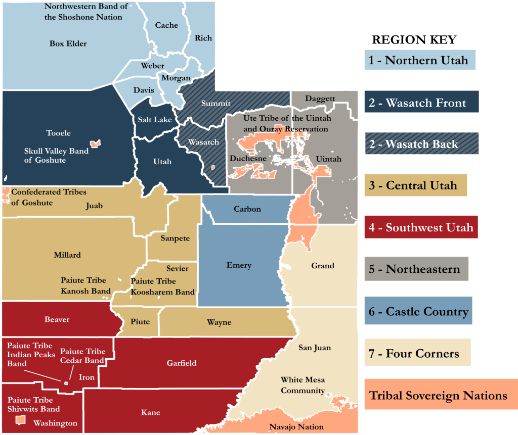
Region 1
Cache County
● New The Bureau of Reclamation, Utah Division of Water Resources, and Cache County are actively monitoring the Hyrum Dam for potential high-flow releases in the Little Bear River that may exceed the safe channel capacity. [Bureau of Reclamation, Interagency Correspondence]
● New Due to the heavy snowpack, the county has also determined that it is both necessary and appropriate to extend the seasonal restrictions on county roads to motorized vehicles. [Cache County]
Morgan County
● New The National Weather Service (NWS) has advised the County that East Canyon Creek will go above flood stage on Sunday and into the first part of next week. The County is preparing and monitoring. [LNO Correspondence]
Region 2
Salt Lake County
● New Draper has declared a local emergency declaration due to the homes sliding. [LNO Correspondence]
● New Salt Lake County (SLCo) has raised its Emergency Coordination Center level of activation to Level III. [LNO
Correspondence]
● New Road closure, Little Cottonwood Canyon SR-210 from 11:00-19:00 on 4/29 for avalanche control work. [UDOT Canyon Twitter]
● New A small landslide occurred on I-80 WB at the summit of Parleys Canyon. No traffic issues were reported. [UDOT Traffic]
● Update SLCo Emergency Management is working with DEM, UDOT, and SLC in finding a solution to protect the water treatment plant in Big Cottonwood Canyon in preparation for potential flooding. [LNO Correspondence]
● Update Residents are invited to come to the Salt Lake County Flood Control Shed to fill sandbags, either for the community to use or to take home on the whole day of April 29th at the Salt Lake County Flood Control Shed. [SLCo]
● Active Due to current hillside conditions, Ann’s Trail in Draper is closed to public use. [Draper City]
Wasatch County
● Update Wasatch County and Heber City are working to find a solution as they divert flood waters from North Creek
to Center Street to help alleviate overwhelming storm drainage systems. The issue they have with doing this is Center Street crosses Hwy 189 and they have over 30,000 vehicles that use the highway per day and can’t shut it down for long periods of time. A meeting was held yesterday that included County, City, DEM, and the Utah National Guard to discuss solutions that may be helpful or effective for the current issue. The UTNG does have some bridging resources but doesn’t feel they would work with their current situation. The concerns are the time to get this on-site, engineering, and cost. [LNO Correspondence]
Region 3
● No significant updates to report at this time.
Region 4
Garfield County
● Update The Sevier River is flowing out of its banks and is flooding out into the lowlands between Panguitch and Old Town hatch. This is expected to increase and is following a normal pattern for the river during runoff. At the present time, no structures or infrastructure are threatened. [LNO Correspondence]
Kane County
● New The emergency manager and a representative from the Dam Safety Group visited a dam above Alton to take pictures and follow up on it as an area of concern. The dam is above the McDonald Lake Dam and they will be making room in the lower dam to ensure its capacity to handle the water from the upper area. The structure has stabilized. [Utah Dam Safety Group, LNO Correspondence]
Region 5
● No significant updates to report at this time.
Region 6/7
Grand County
● New High potential of flooding at the University of Utah’s Field Station at Rio Mesa along the Dolores River. The site has many structures at risk for flooding due to spring runoff combined with big spill releases from McFee Reservoir scheduled for May 4th and is factored into the river forecast. Another release is scheduled for May 5th but has not yet been factored into the calculations. No additional requests at this time. [LNO Correspondence]
Tribal Nations
● No significant updates to report at this time.
Impact and activity information is provided by Local Emergency Management partners, the State Emergency Response Team (SERT), and private and non-profit partners through various coordinating communication channels. This is a developing situation, and information may quickly become outdated. Additional situation reports may be made as verified information becomes available.


SHARE THIS STORY