Protecting Utah
Daily Flood Situation Report April 28
Significant State Activity
Other Immediate Concerns
● Active Current flood risk is spring runoff, increasing streamflows, and snowmelt. Some reported flood-related landslides being monitored.
Current State (SERT) Actions
- The Division of Emergency Mgmt. continues to provide media engagement and media coordination with other partners, in order to provide emergency public information as needed to the flood response efforts.
- Active The State EOC is now at Activation Level 2-Partial Activation.
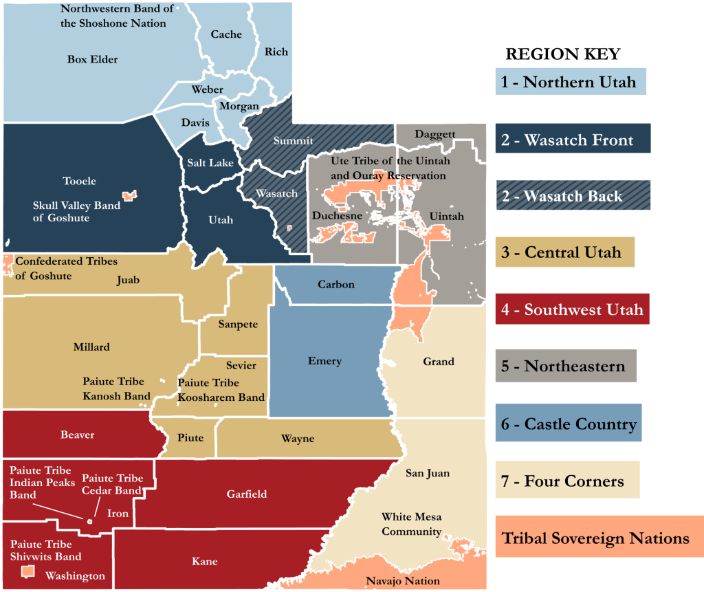
Region 1
● No significant updates to report at this time.
Region 2
Salt Lake County
● New Residents are invited to come to the Salt Lake County Flood Control Shed to fill sandbags, either for the community to use or to take home on the afternoon of April 28th and the whole day of April 29th at the Salt Lake County Flood Control Shed. [SLCo]
● Active Due to current hillside conditions, Ann’s Trail in Draper is closed to public use. [Draper City]
Region 3
● No significant updates to report at this time.
Region 4
Beaver County
● New Sandbags are being filled and citizens are picking them up that live in flood-prone areas. Clearing has been done along Beaver Canyon waterways. A backhoe is also positioned at the diversion dam to remove debris from the grates. [LNO Correspondence]
Garfield County
● New The higher elevation snow is starting to melt. Panguitch Lake is still frozen. The Sevier River is rising, reaching the top of its banks, and spreading into low-lying pasture lands. [LNO Correspondence]
Iron County
● New Monitoring Cedar Canyon drainage, Coal Creek, Parowan Canyon drainage, and Patagonah Canyon drainage. No flooding issues at this time. Heavy equipment has been staged at possible choke points for debris. They are filling sandbags and making them available to the public. [LNO Correspondence]
Kane County
● New They are monitoring the melt from the Duck Creek area. Kanab Creek is flowing higher but not out of its banks. Sandbags have been placed around the county for residents to use. No flooding at this time. Low water crossings are subject to closures at any time. [LNO Correspondence]
Washington County
● New Monitoring Baker Dam and the melt from the Pine Valley Mountains that feed the Santa Clara River. Monitoring the Virgin River and its flow out of Kane County and Zion National Park. No flooding at this time. [LNO Correspondence]
Region 5/6/7/Tribal Nations
● No significant updates to report at this time.
Impact and activity information is provided by Local Emergency Management partners, the State Emergency Response Team (SERT), and private and non-profit partners through various coordinating communication channels. This is a developing situation, and information may quickly become outdated. Additional situation reports may be made as verified information becomes available.
| EMERGENCY DECLARATIONS | |||
| JURISDICTION | EXPIRES | JURISDICTION | EXPIRES |
| Emigration Canyon | 5/12/23 | Morgan County | 5/18/23 |
| Juab County | 5/17/23 | Salt Lake City | 5/12/23 |
| Kaysville City | 5/19/23 | Salt Lake County | 5/13/23 |
| Millard County | 8/31/23 | State of Utah | 5/18/23 |
| Millcreek City | 5/13/23 | Washington County | 5/19/23 |





SHARE THIS STORY